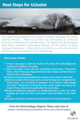
Flood Mapping Project
Overview of the Project
In February 2019, Council received a report from District staff requesting support for a funding application to the Community Emergency Preparedness Fund through the Union of BC Municipalities (UBCM) for a flood mapping project for Ucluelet.
The purpose of the District of Ucluelet Flood Mapping Project was to engage a qualified professional engineering consultant experienced in coastal engineering to develop a flood risk assessment, flood plain mapping, establish a flood construction level (FCL), identify sea level rise planning areas, and identify flood hazards for the development of future land use policy.
The project was designed to help the District of Ucluelet meet its responsibilities as laid out in the updated Provincial Flood Hazard Area Land Use Management Guidelines, and to provide updated flood risk data accounting for climate change and future sea level rises.
Council gave their full support to the project and directed staff to proceed with the funding application and project.
Read the Flood Mapping Report to Council and Community Emergency Preparedness Fund Application (February 2019)
Tsunami Risk Tolerance - Interim Policy
Timeline
A Request for Proposals (RFP) process was initiated in September 2019. The contract was awarded to Ebbwater Consulting Inc. in November 2019. The project and final reports were completed in June 2020.
Flood Risk Data Gathering and Analysis
The project consisted of key activities and modelling designed to inform the flood mapping and flood risk reports:
- Definition of the Designated Storm(s) and the associated winds and storm surge
- A flood risk assessment and the Designated Flood Level, considering sea level rise, tide conditions and storm surge
- Characterisation of the incident wave climate approaching the shoreline
- Determination of wave effects and overtopping rates at the shoreline
- Calculation of the Flood Construction Levels (FCL)
- Determination of the location and quality of structures, people and assets that might be affected by flood within the District of Ucluelet area
Once all data and modelling had been completed, the new data will be used to:
- Inform community members and stakeholders of project findings and recommendations
- Update District of Ucluelet policies and bylaws such as the Official Community Plan (OCP) and Zoning Bylaw
- Improve community preparedness for flood emergencies
The data could also be used to inform the establishment of no-build areas, flood construction levels that account for predicted sea level rises and future designation of development areas that are outside of hazardous flood risk zones.
Project Reports, Video and Maps
Reports and maps can be found on our Technical Report, Appendices and Maps page.
The Tsunami Visualisation Video can be view on the Tsunami Flood Modelling Video page along with brief explanations of the different tsunami flooding scenarios.
View the Public Exhibit Posters
Links to Additional Background Resources
More Information
If you have any comments or questions regarding the Flood Mapping Project, please contact Bruce Greig or John Towgood in the Community Planning Department.
Please note: We gratefully acknowledge the funding of this project by the Union of BC Municipalities (UBCM) from the Community Emergency Preparedness Fund.

Technical Flood Mapping Reports
Main Report
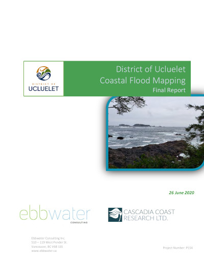
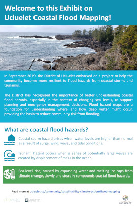
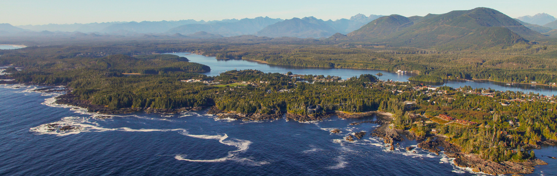
The District of Ucluelet is located on the Ucluth Peninsula between Barkley Sound and the Pacific Ocean. The coastal setting means that the area is exposed to coastal flood hazards from storms and tsunamis. Climate change brings further hazards including sea level rise (SLR). The District of Ucluelet recognises the importance of understanding coastal flood hazards and commissioned Ebbwater Consulting Inc. and its partner Cascadia Coast Research Ltd. to produce modern flood maps to better understand these hazards.
The final report will be used to identify ways to mitigate the risks associated with floods and tsunamis, and to help with emergency response planning and planning policy development.
The Technical Report, Appendices and Map Atlas Series are provided here. Public Exhibit materials are currently in development and will be available on the website shortly.
Report Appendices
The main report is supported by the following appendices:
- Appendix A - Coastal Storm and Tsunami Hydrodynamic Modelling Analysis
- Appendix B - Coastal Erosion Preliminary Data Evaluation
- Appendix C - Coastal Flood Hazard Map Atlas (see below for map downloads)
- Appendix D - Coastal Storm Flood Depths and Flood Construction Level Differences
Appendix C - Map Atlas Series
Explanations of these maps and the scenarios illustrated can be found in the main project report. For an explanation of the Flood Hazard Maps, please refer to page 47. For an explanation of the Tsunami Flood Hazard Maps, please refer to page 56.
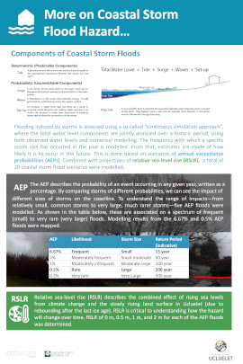
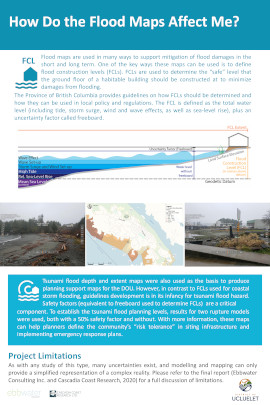
Series 1 - Coastal Storm Flood Hazard (Flood Depth and Extent)
This series of maps provide essential information on where water may go in a flood, and how deep that water might be. The maps indicate where people, infrastructure, and cultural and environmental assets are most exposed to a flood hazard.
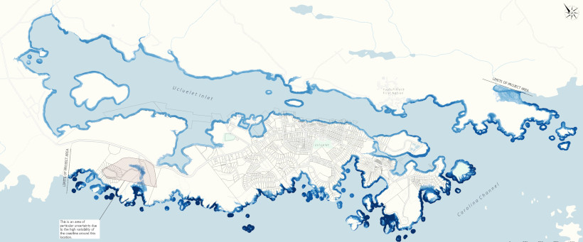
Download Coastal Flood Hazard Maps High Resolution PDF File (12MB)
Series 2 - Coastal Storm Flood Planning Support (Sea Level Rise and Flood Construction Level)
This series of maps shows land that is not currently exposed to flooding from designated storms but will likely be in the future with sea level rises. The Flood Construction Level (FCL) is used to establish the elevation of the underside of a wooden floor system or top of concrete slab for habitable buildings.
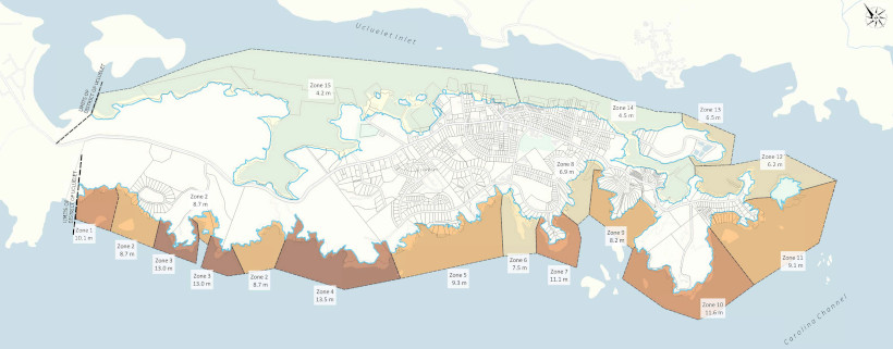
Download Coastal Storm Flood Planning Support Maps High Resolution PDF File (18MB)
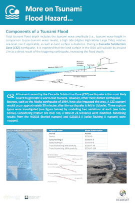
Series 3 - Tsunami Flood Hazard (Flood Depth and Extent)
This series of maps provide essential information on tsunami flood depths and extents as a result of a megathrust earthquake.
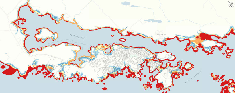
Download Tsunami Flood Hazard Maps High Resolution PDF File (14MB)
Series 4 - Tsunami Flood Planning Support (Tsunami Flood Planning Level and Vulnerability Zones)
The Tsunami Flood Planning level is the elevation below which areas are considered exposed to a tsunami hazard. The Tsunami Flood Hazard Vulnerability Zones are related to the vulnerability of people as they walk or drive through flood waters, or as they remain inside a structure during a tsunami flood event.
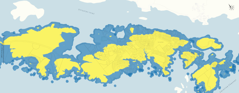
Download Tsunami Flood Planning Support Maps High Resolution PDF File (18MB)
Copyright Notice
This report is provided under a Creative Commons Licence CC BY-NC-Sa 4.0 with the exception of any content supplied by third parties. This license allows users to copy and redistribute the material in any medium or format, under the following terms:
- Provide appropriate credit by citing this report.
- Do not use the material for commercial purposes.
- If you remix, transform, or build upon the material, you must distribute your contributions under the same license.
Suggested report citation: Ebbwater Consulting Inc. and Cascadia Coast Research Ltd. (2020): District of Ucluelet Coastal Flood Mapping. Prepared for the District of Ucluelet.
More Information
If you have any comments or questions regarding the Flood Mapping Project, please contact Bruce Greig or John Towgood in the Community Planning Department.
Tsunami Flood Modelling Video
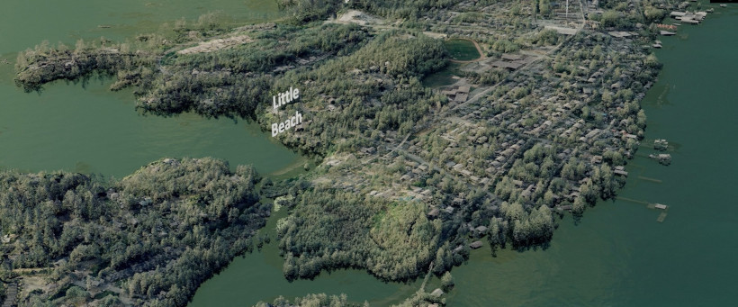
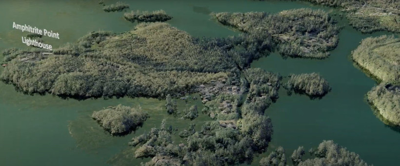
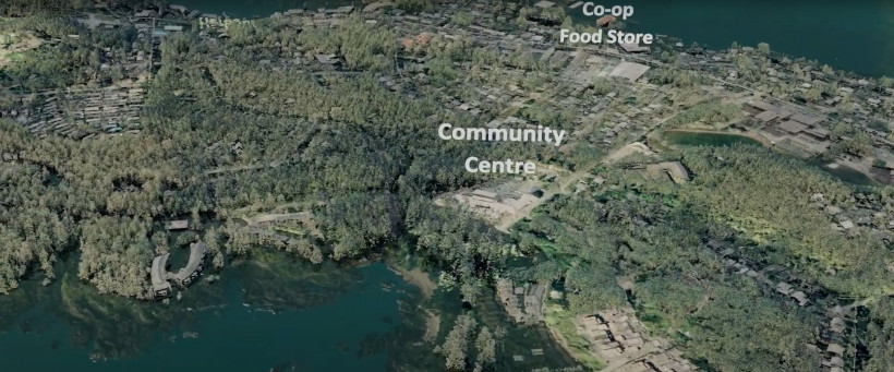
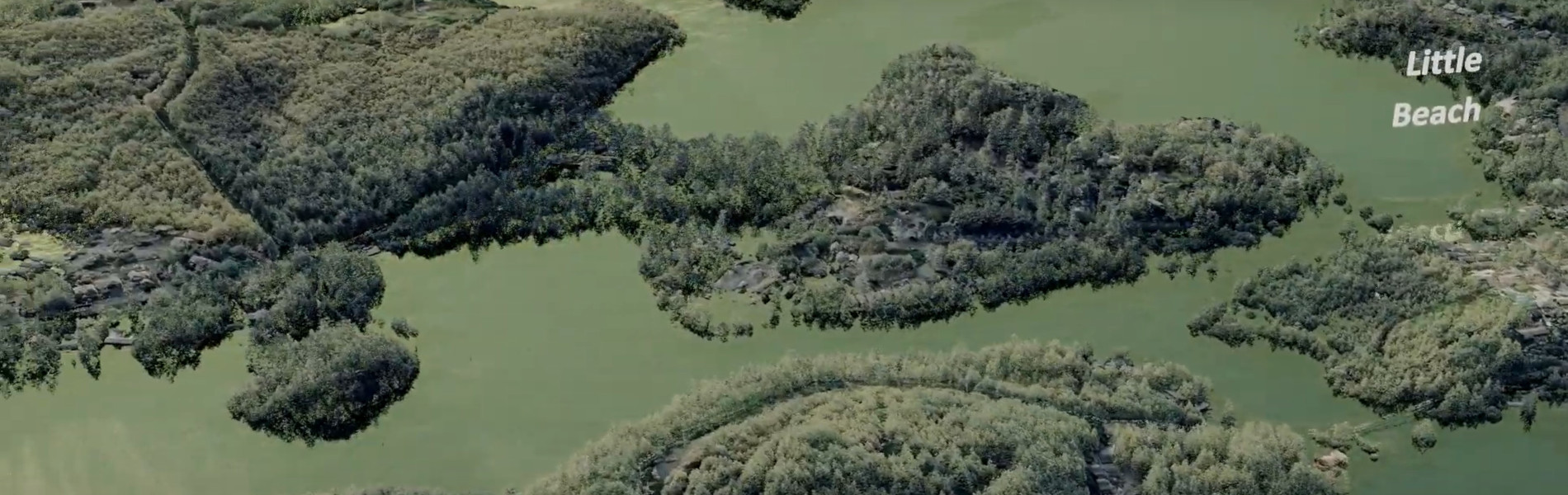
The Tsunami Flood Modelling Video was commissioned as part of the Ucluelet Flood Mapping Project to demonstrate the effects a tsunami wave could have on Ucluelet. The video depicts the predicted outcomes of the two modelled Tsunami events completed as part of the project. The video was created using a 3-D laser scanning techniques and orthographic imagery by Andrew Plowright.
Scenario V1 - No Tsunami (0.08s)
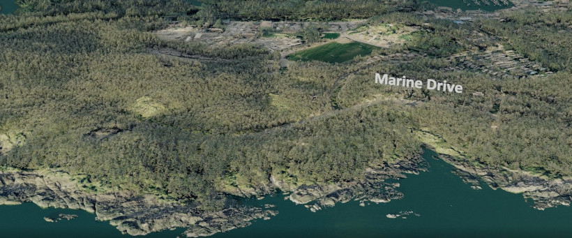
The first part of the video looks over the Ucluelet Peninsula without any rise in the sea level and shows what we typically see near high tide. Note the clarity of the information with the forests, roads, buildings and even hydro lines being visible and to scale.
Scenario V2 - Smaller Tsunami (0.53s)
The second scenario shown in the video models the sea level rise of a buried rupture fault event along the Cascadia Subduction Zone. This comparative case model has been used in previous studies and allows the results to be compared with other tsunami flood hazard maps from around the region. This model simulation also corresponds to the lower end of the tsunami amplitudes that can be expected, with the least impact to the shore.
In this model, the water level has now gone inland, and you can see the reflections within the trees and in amongst the buildings. It is important to note where water is now visible across roads and highways so that you can organize a personal and neighbourhood emergency plan.
Scenario V3 - Larger Tsunami (1min 35s)
Sea level is increased further using a worst-case (relative to this project only) splay faulting rupture model in the final part of the video. This higher water level further affects the community’s roads and infiltrates even more inland.
We hope this demonstration video will emphasise the importance of personal, neighbourhood, and community preparedness and inform on the need to integrate emergency planning into current and future land use decisions.
More Information
Section 6 of the Final Report and the Map Atlas (Appendix C) contains more in-depth information on the Tsunami Flood Hazards affecting Ucluelet and the models used to predict the sea level rises.
If you have any comments or questions regarding the Flood Mapping Project, please contact Bruce Greig or John Towgood in the Community Planning Department.
Disclaimer
The content in this video has been simplified for visualisation purposes. The terrain and water levels represented here may not exactly match the modelled tsunami flood scenarios. For example, the calm water in the video only indicates the maximum water levels (as still water). The actual tsunami waves approaching and overtaking the coastline are not shown. The tsunami visualisations include 1m of relative sea level rise caused by climate change.
Please refer to the Coastal Flood Mapping Report for details on methods, results, and map outputs. Ebbwater Consulting Inc. and Cascadia Coast Research developed the flood mapping in accordance with generally accepted engineering practices and with full understanding of applicable natural hazard and mapping guidelines in the Province of British Columbia. The mapping outputs were developed for the District of Ucluelet, and the consulting team denies any liability to others.
Public Information Exhibit
The Public Information Exhibit will be available to view from mid-August. The posters presented at the exhibit are available on this page for downloading.
Location: Ucluelet Community Centre, Dance Studio
Date: 17th August until mid-September
Time: During Community Centre opening hours (10am - 3.30pm)
COVID-19 Protocol: Maximum of 4 people in the room, maintaining 2m social distancing
Please note that the exhibit will not be staffed, and any feedback or requests for more information can be emailed to info@ucluelet.ca.
Poster Exhibits
Clicking on the poster image will open a seperate browser tab for easier viewing of the poster.
| Poster One |
|
Poster Two |
|
Poster Three |
 |
|
 |
|
 |
| Poster Four |
|
Poster Five |
|
Poster Six |
 |
|
 |
|
 |
Download All Posters in One PDF Document (4MB)
Watch the Tsunami Flood Modelling Video
More Information
If you have any comments or questions regarding the Flood Mapping Project, please contact Bruce Greig or John Towgood in the Community Planning Department.


 Canada Post Service Disruption - May 21, 2025
Canada Post Mail Service Disruption:
In light of a potential Canada Post service disruption coinciding with the scheduled distribution of property tax...
Canada Post Service Disruption - May 21, 2025
Canada Post Mail Service Disruption:
In light of a potential Canada Post service disruption coinciding with the scheduled distribution of property tax...  Ucluelet Business Licences: Renew Before May 31, 2025 to Avoid Late Penalties
If you operate a business in Ucluelet, here’s a quick update: business licence renewals are now underway for the...
Ucluelet Business Licences: Renew Before May 31, 2025 to Avoid Late Penalties
If you operate a business in Ucluelet, here’s a quick update: business licence renewals are now underway for the...